Agency-described public trail
Named CSD multi-use routes and trailheads described by the District. Use the current CSD guide and on-site signs before setting out.

Lifestyle · Trails & outdoor access
Source-led orientation
This branded field map frames the official CSD pocket-map data for a Serrano first visit. It is intentionally an orientation aid—not a legal-access determination, a property-line map, or turn-by-turn navigation.
Use it in two steps: orient here, then open the current CSD guide and follow the actual signs at the access point. Conditions, gates, easements, construction and trail permissions can change.
Open official CSD trail guide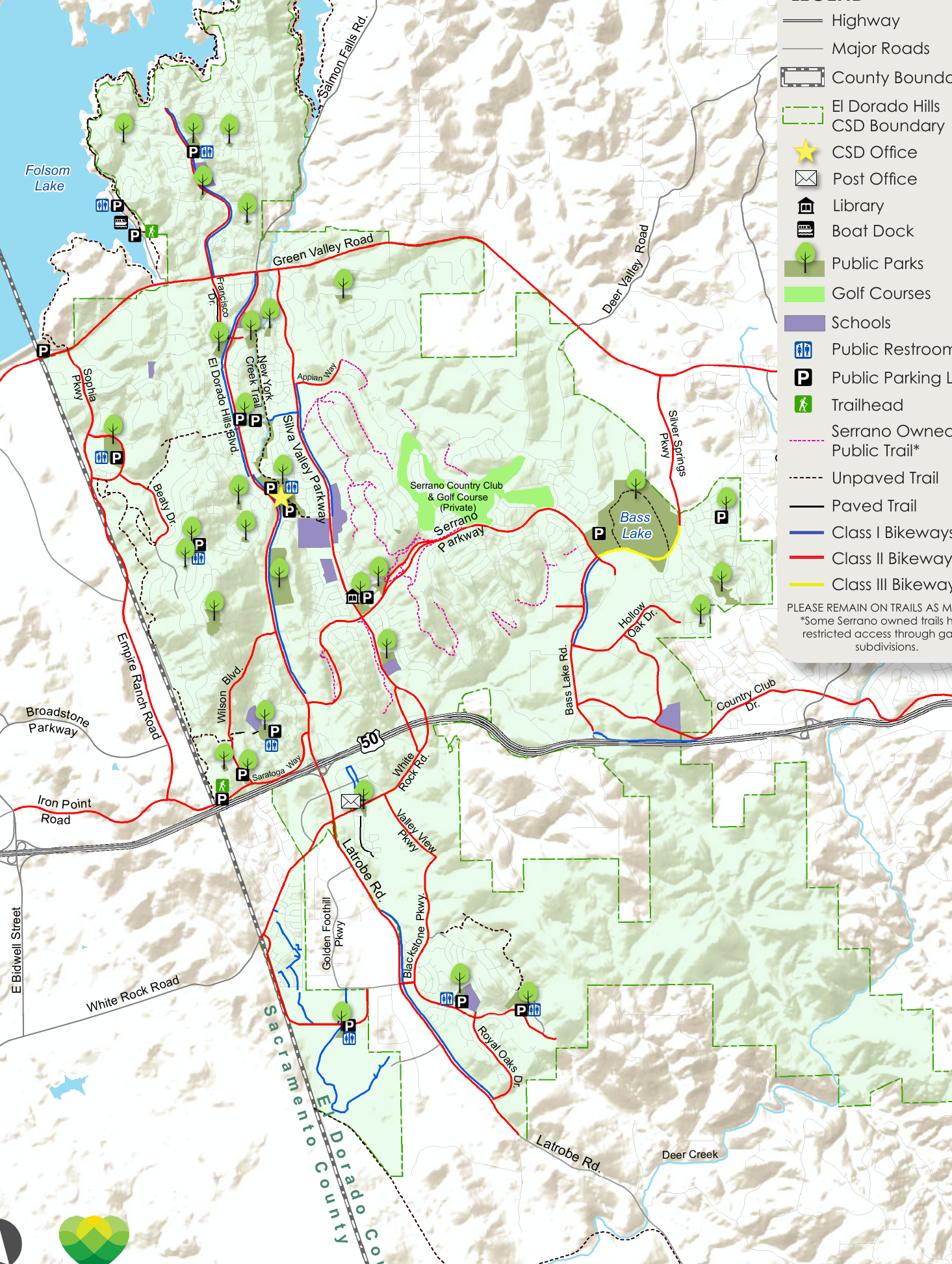
Live Serrano field map
Serrano & outdoor access
Styled from the official CSD pocket-map area. Map edition: 2022 official pocket-map edition.
The underlying map preserves the agency’s route and access notation. The Live Serrano framing simplifies how to read it; it does not redraw, expand, or certify access rights.
Access legend
Named CSD multi-use routes and trailheads described by the District. Use the current CSD guide and on-site signs before setting out.
The CSD map includes Serrano-maintained publicly accessible unpaved trails with permission to map them. This does not establish that every Serrano path is public or unrestricted.
The CSD guide distinguishes separated Class I paths, striped Class II lanes, and Class III shared-road routes. They are transportation context, not a promise of a continuous leisure trail.
Private roads, gated subdivisions, easements, construction, weather, and trail conditions can affect access. Remain on marked trails and follow current signs.
The CSD guide notes that some Serrano-owned trails have restricted access through gated subdivisions. Stay on marked trails, respect private property, and confirm current field conditions.
Agency-described public multi-use trail
EDHCSD describes a 1.5-mile, 28-acre unpaved north–south trail alongside New York Creek, connecting Art Weisberg Park/Jackson Elementary context with Community The Park/Oak Ridge High School context.
Read official trail descriptionAgency-described public recreation trail
A mostly decomposed-granite and concrete connection from Crescent Ridge/Platt Circle through Saratoga Estates toward the larger Promontory system. The CSD places the Saratoga Trailhead at Saratoga Way and Saratoga Estates.
Read official trail descriptionCSD-described system connection
The District describes the wider Promontory system as extending from Saratoga Way to Alexandra Drive, approximately three miles. Confirm the current permitted route, gate conditions, and signage from the exact access point.
Read official trail descriptionPublic-to-HOA trail connection
EDHCSD identifies a multi-use trail near Murray Homestead Park that connects with the Highland View HOA trail. This is a connection note, not a statement that every HOA segment has the same public access.
Read official trail descriptionAgency-maintained east–west connection
EDHCSD describes a 1.1-mile trail from El Dorado Hills Boulevard to Beatty Drive, with a maintained segment under an easement agreement on Promontory HOA-owned land. It also connects toward a County Class I path and Promontory Community Park via sidewalk.
Read official trail descriptionField-use rule
The official CSD guide maps publicly accessible paths, trails and bikeways, including Serrano-maintained publicly accessible unpaved trails mapped with permission. That useful distinction is not the same as a promise that every nearby open-space path, private road, gate, club area or future segment is open to every visitor.
For a home-specific question, bring the exact address and route to Chris Wolfe. For an access or legal-right question, use current agency, association and on-site sources.
Ask a Serrano location questionFor a current map, official descriptions and updates, rely on the El Dorado Hills Community Services District rather than a static editorial page.
Open official CSD trails page